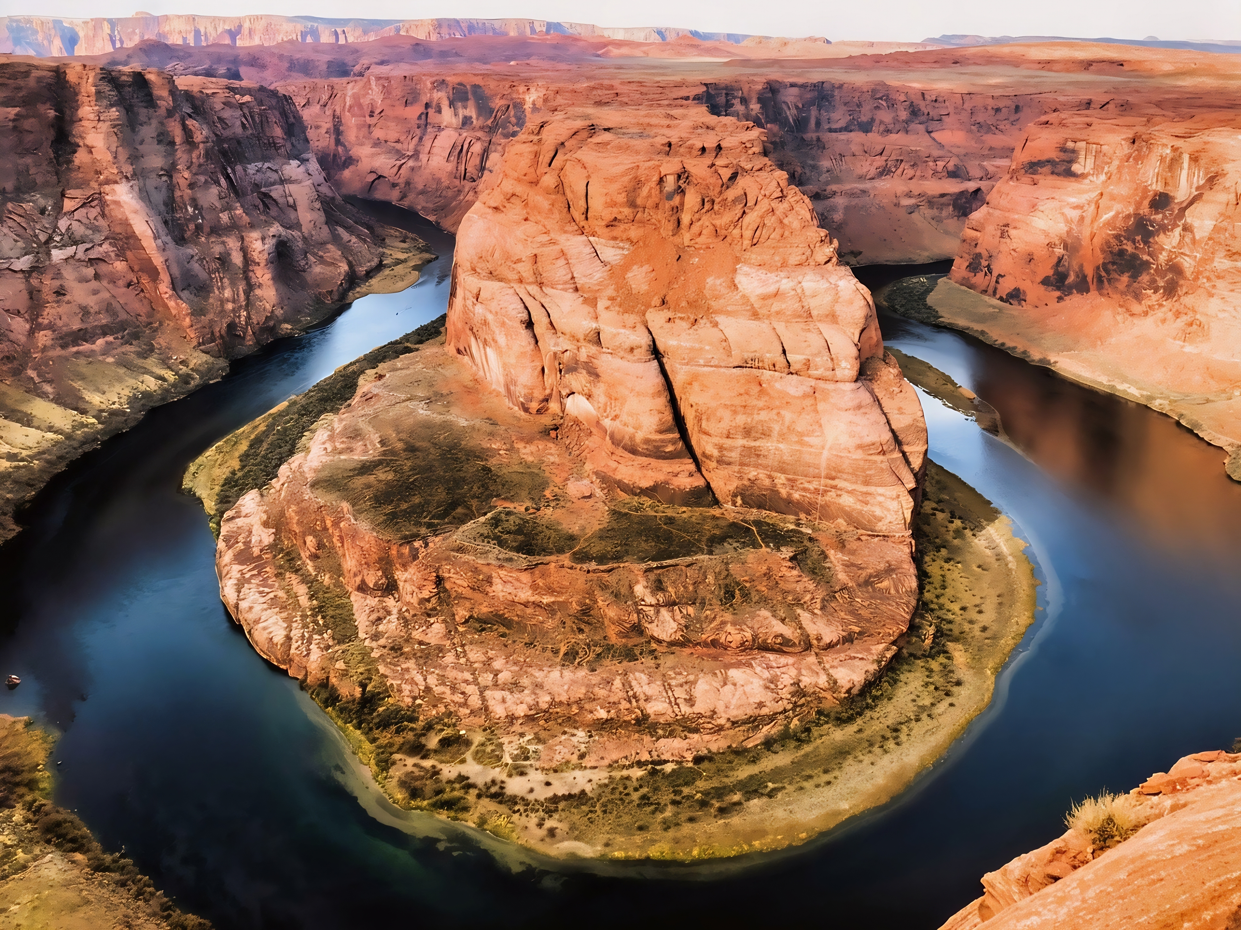

Horseshoe Bend, just south of Page, Arizona, is one of the most recognizable landscapes of the American Southwest and lies within Glen Canyon National Recreation Area. Here, the Colorado River makes an extraordinary roughly 270-degree turn around a massive sandstone promontory, flowing about 1,000 feet (305 m) below the rim. The site is an excellent example of an entrenched or incised meander—a river bend that became deeply cut into bedrock as the Colorado River eroded downward while the Colorado Plateau was uplifted. The National Park Service explains that the river’s meandering course became increasingly entrenched as it carved through the rising plateau, eventually producing the dramatic canyon visible today (National Park Service [NPS], 2024).
For travelers, Horseshoe Bend is conveniently reached from U.S. Highway 89, about five miles south of Page. From the city-operated parking area, visitors follow a 1.5-mile (2.4-km) round-trip hardened trail to the overlook. Two shade structures are located along the route, but shade is very limited at the overlook, and much of the canyon rim remains unprotected by railings. Water, sun protection, sturdy footwear, and avoiding the hottest part of the day are especially important in this exposed desert environment. The parking area requires a separate City of Page fee, and National Park Service passes do not cover that fee (NPS, 2026a). The landscape also has a much longer human history than its modern popularity suggests: archaeological evidence shows that people have used the broader Glen Canyon region for more than 10,000 years, including ancestral Indigenous cultures, while the Navajo, Hopi, Paiute, Zuni, Ute and other affiliated peoples retain cultural connections to the region today (NPS, 2026b).

Although the bare sandstone cliffs dominate the scenery, Horseshoe Bend belongs to a surprisingly diverse Colorado Plateau ecosystem. Vegetation varies according to soil, bedrock, elevation and access to water, with drought-adapted desert plants contrasting with much greener riparian vegetation along the Colorado River. Biological soil crusts are also an important component of the surrounding desert and can stabilize soil and support ecosystem processes, making it important for visitors to remain on established routes where possible (NPS, 2026c). Wildlife throughout Glen Canyon includes desert bighorn sheep, coyotes, bobcats, bats, rodents and numerous reptiles, while more than 300 bird species live in or migrate through the recreation area. Lizards such as desert spiny, side-blotched and eastern collared lizards are among the reptiles adapted to the region’s intense heat and limited water (NPS, 2026d).
Recent research shows that the Colorado River beneath Horseshoe Bend is not simply a scenic feature but part of a rapidly changing and intensively studied river ecosystem. In 2026, U.S. Geological Survey scientists reported ongoing use of environmental DNA (eDNA) in the Colorado River below Glen Canyon Dam and in Lake Powell to detect invasive warm-water fish before they become established, particularly species such as smallmouth bass that could threaten native fishes including humpback chub and razorback sucker (U.S. Geological Survey [USGS], 2026a). Researchers have also published high-resolution measurements of water-surface and riverbed elevations along 282 miles of the Colorado River, providing an unusually detailed baseline for understanding how dams, sediment movement and natural processes influence the river’s changing physical landscape (USGS, 2026b). Together, these studies make Horseshoe Bend more than a spectacular photography stop: it is a window into the intertwined geology, ecology, human history and modern environmental challenges of the Colorado River system.


References:
National Park Service. (2024). Horseshoe Bend on the Colorado River. Glen Canyon National Recreation Area. National Park Service — Horseshoe Bend
National Park Service. (2026a). Horseshoe Bend. Glen Canyon National Recreation Area. NPS — Visiting Horseshoe Bend
National Park Service. (2026b). History & culture. Glen Canyon National Recreation Area. NPS — Glen Canyon History & Culture
National Park Service. (2026c). Plants. Glen Canyon National Recreation Area. NPS — Plants of Glen Canyon
National Park Service. (2026d). Animals. Glen Canyon National Recreation Area. NPS — Animals of Glen Canyon
U.S. Geological Survey. (2026a). Early detection of aquatic threats: eDNA research in the Colorado River ecosystem & Lake Powell. USGS — Colorado River eDNA Research
U.S. Geological Survey. (2026b). Continuous and high-resolution longitudinal profiles of the water surface and riverbed elevation for 282 miles of the Colorado River from Lees Ferry to Pearce Ferry, Arizona, 2021. USGS — Colorado River Water-Surface and Riverbed Research
AI Disclosure Statement:
Artificial intelligence tools were used in the creation of this page, including elements such as writing, image enhancement, voice enhancement, and/or editing support. All final creative decisions were made by the creator.

Leave a Reply