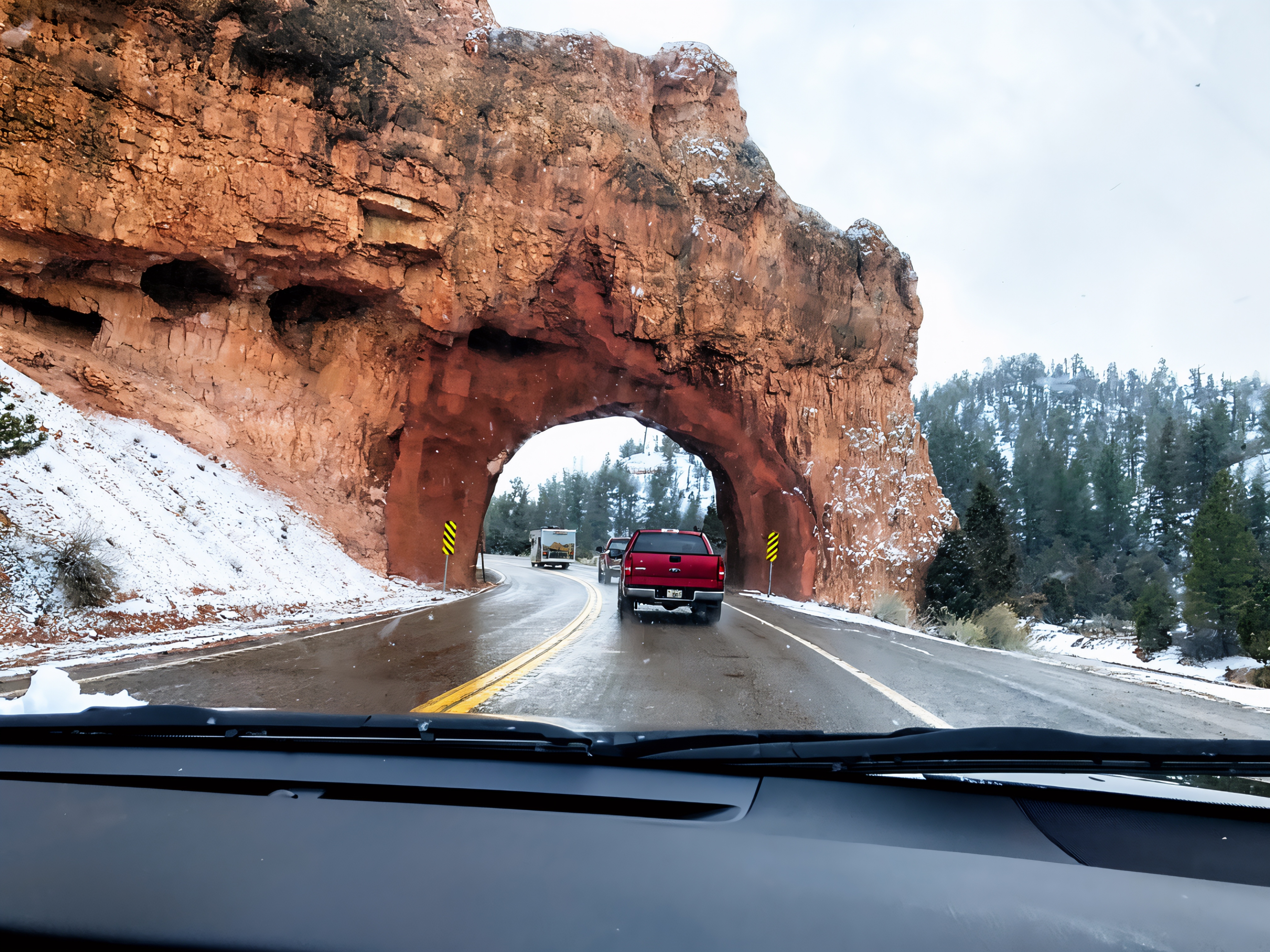

The Red Canyon Arches, also called the Red Canyon Tunnels, are two short passageways through orange-red rock along Utah’s Scenic Byway 12 in Dixie National Forest. Located between Panguitch and Bryce Canyon, they make a memorable gateway to a landscape of cliffs, pine trees, and hoodoos—the slender rock pillars characteristic of this region. Although their rounded openings resemble natural arches, workers excavated them to carry the highway through existing rock formations. Travelers can experience both tunnels directly from their vehicles, making them an accessible highlight of a southern Utah road trip (Bryce Canyon Country, n.d.; Utah Department of Transportation [UDOT], 2025).
For a closer look, use designated roadside pullouts and keep clear of the roadway when taking photographs. The nearby Tunnel Trail climbs to a viewpoint overlooking the tunnels and the highway winding through the canyon. Visitors can also explore the Pink Ledges interpretive trail or enjoy the paved Red Canyon Bicycle Trail alongside the scenic corridor. The Red Canyon Visitor Center provides maps and information about the surrounding landscape, although its services are seasonal. Visiting Red Canyon does not require a national park entrance fee, and combining the tunnels with a short walk makes this more than a quick drive-through stop (Bryce Canyon Country, n.d.).

Historically, these rock passageways became associated with the early development of automobile access to Bryce Canyon and have served as recognizable gateways for roughly a century. Their preservation now combines traditional road maintenance with modern engineering. UDOT has used drone photographs and LiDAR, a laser-based surveying technology, to create detailed three-dimensional representations of the arches. Engineers compare these measurements and sensor readings to watch for movement, deformation, and rockfall. Vehicle collisions and scrapes have also damaged portions of the rock and its protective shotcrete, a sprayed concrete coating. This monitoring helps engineers assess changes while preserving the landmarks’ distinctive appearance (UDOT, 2025).
For science lovers, the surrounding cliffs reveal a much older story. Red Canyon exposes the Claron Formation, the same geological formation responsible for much of Bryce Canyon’s scenery. Its limestone-rich layers originated in ancient lakes and associated river environments, where sediment accumulated and eventually hardened into rock. Tectonic uplift later raised these deposits, exposing them to weathering and erosion (Bryce Canyon Country, n.d.; National Park Service, 2024). Across the nearby Bryce landscape, water enters cracks, freezes, and expands, gradually breaking the rock apart through a process called frost wedging. Runoff carries away loosened material, helping shape fins and hoodoos. These processes explain the evolving natural landscape surrounding the excavated tunnel openings (National Park Service, n.d.).
References
Bryce Canyon Country. (n.d.). Red Canyon on Scenic Byway 12. https://www.brycecanyoncountry.com/red-canyon-on-scenic-byway-12
National Park Service. (n.d.). Wall and narrows. https://www.nps.gov/brca/learn/nature/wallandnarrows.htm
National Park Service. (2024). Deciphering nature’s palette wayside. https://www.nps.gov/places/deciphering-nature-s-palette-wayside.htm
Utah Department of Transportation. (2025). UDOT uses drones, LiDAR to monitor 100-year-old southern Utah arches over SR-12. https://connect.udot.utah.gov/2025/06/23/udot-uses-drones-lidar-to-monitor-100-year-old-southern-utah-arches-over-sr-12
AI Disclosure Statement:
Artificial intelligence tools were used in the creation of this page, including elements such as writing, image enhancement/generation, voice enhancement, and/or editing support. All final creative decisions were made by the creator.

Leave a Reply