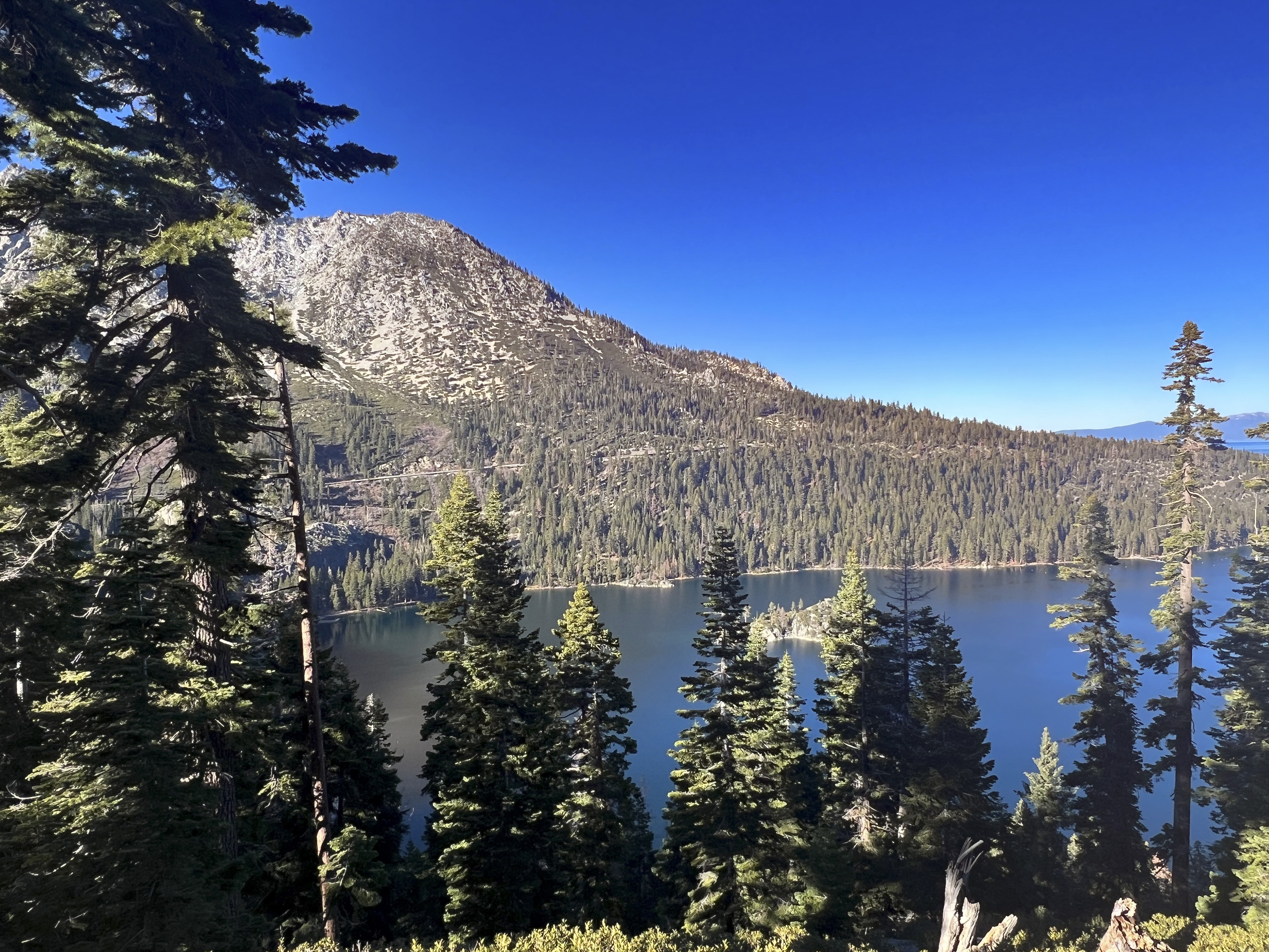

Inspiration Point is a scenic roadside viewpoint along California Highway 89, overlooking Emerald Bay on Lake Tahoe’s southwestern shore. From this elevated location, visitors can enjoy a sweeping view of the bay’s blue-green water, steep forested slopes, rugged granite shoreline, and the distant mountains surrounding Lake Tahoe. The most recognizable feature is Fannette Island—the only island in Lake Tahoe—which rises about 150 feet above the water. A small stone Tea House built in 1928–1929 stands at its summit (California State Parks, 2026a, 2026b).
Because Inspiration Point is beside Highway 89, visitors can experience its panorama without completing a long hike. Summer and early autumn generally offer the easiest access, but the area becomes extremely busy during the summer, so arriving early can make parking easier. Mountain weather can change suddenly, and snow or ice may affect travel during colder months. Travelers wishing to explore beyond the viewpoint can continue to the nearby Vikingsholm parking area, where a steep one-mile trail descends about 500 feet to Vikingsholm, the bay’s famous Scandinavian-style mansion; visitors must climb the same trail to return (California State Parks, 2026a, 2026c).

Emerald Bay’s shape is largely the work of ancient glaciers that moved through the Sierra Nevada, eroding the landscape and leaving behind a deep, curved basin surrounded by granite. Fannette Island survived because its resistant granite core withstood much of the glacial erosion. The park is recognized as a National Natural Landmark because its scenery clearly displays glacier-carved granite and mountain-building processes. Another interesting feature hidden below the water is the Emerald Bay Maritime Heritage Trail, which protects historic boats and barges associated with early twentieth-century recreation and the construction of Vikingsholm (California State Parks, 2026b, 2026d; Gardner et al., 2000).
The surrounding ecosystem changes from mixed-conifer forest and shrubs on the slopes to aquatic and shoreline habitats around the bay. Visitors may see ospreys and bald eagles above the water, while American black bears and bobcats inhabit the nearby forests; wildlife should be observed from a safe distance, and food must never be left accessible to bears (California State Parks, 2026a). Recent UC Davis research reported that Lake Tahoe’s average water clarity reached 69.2 feet in 2025, but unusually high numbers of suspended particles—possibly including microscopic algae, picoplankton, and the tiny diatom Cyclotella—may still reduce summer clarity. Scientists are also using advanced drone imaging to study shoreline algae and investigating how climate warming and wildfire smoke affect the lake’s water quality and food web (UC Davis Tahoe Environmental Research Center, 2026).


References:
California State Parks. (2026a). Emerald Bay State Park.
California State Parks. (2026b). Fannette Island.
California State Parks. (2026c). Vikingsholm.
California State Parks. (2026d). Emerald Bay Maritime Heritage Trail.
Gardner, J. V., Mayer, L. A., & Hughes Clarke, J. E. (2000). Morphology and processes in Lake Tahoe (California–Nevada). Geological Society of America Bulletin, 112(5), 736–746.
UC Davis Tahoe Environmental Research Center. (2026). Tahoe: State of the Lake 2026.
AI Disclosure Statement:
Artificial intelligence tools were used in the creation of this page, including elements such as writing, image enhancement/generation, voice enhancement, and/or editing support. All final creative decisions were made by the creator.

Leave a Reply