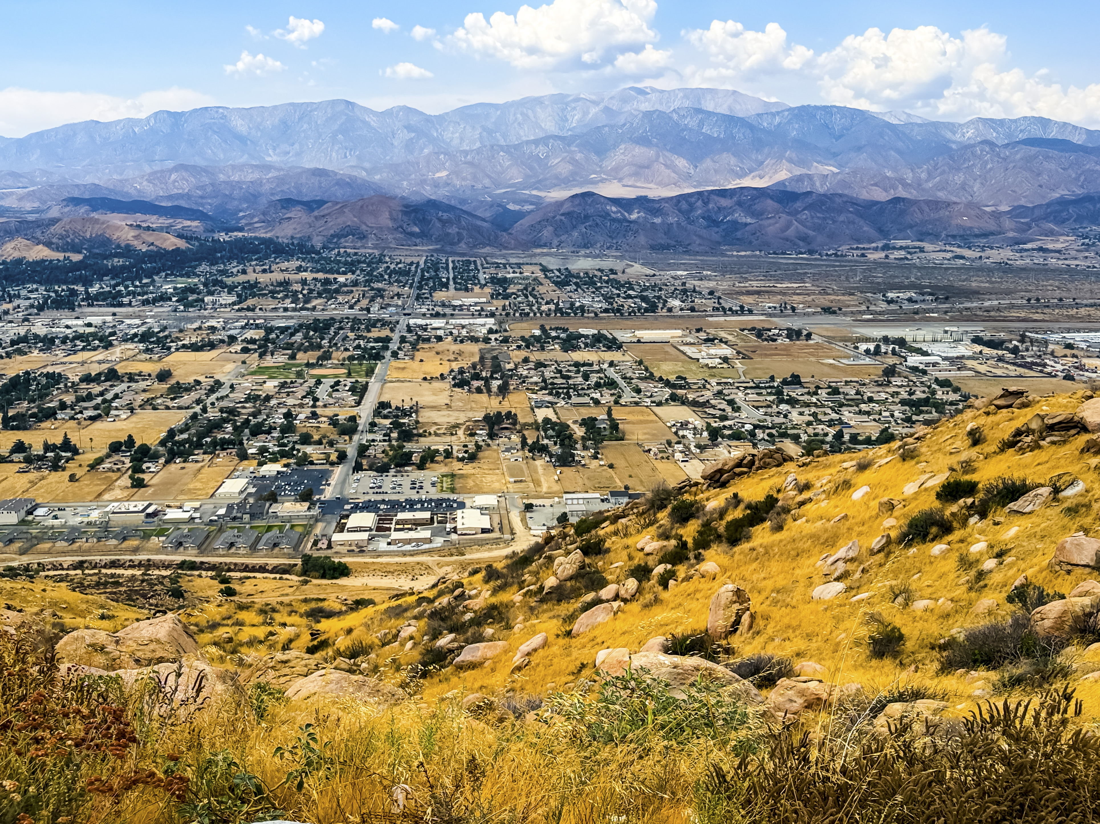

The San Gorgonio Pass near Banning, California, is a dramatic natural corridor between the San Bernardino Mountains to the north and the San Jacinto Mountains to the south. Interstate 10 crosses the pass, making it one of the major transportation gateways between the Inland Empire and the Coachella Valley. The surrounding mountains rise thousands of feet above the pass, creating an impressive transition from inland valleys to the desert. The same topography funnels strong westerly winds through the gap, which is why the eastern San Gorgonio Pass has become one of California’s major wind-energy regions and is easily recognized by its large fields of wind turbines (U.S. Geological Survey [USGS], 2024; California Energy Commission [CEC], n.d.).
For travelers, the pass offers much more than scenery from I-10. Near Banning, Gilman Historic Ranch and Wagon Museum has hiking trails, gardens, historic buildings, and viewpoints overlooking the pass, while State Route 243 climbs south from Banning into the higher forests of the San Jacinto Mountains. Farther east, visitors can leave I-10 for Whitewater Canyon, an access point to Sand to Snow National Monument, where hiking, wildlife watching, photography, camping, and sections of the Pacific Crest Trail provide opportunities to explore the landscape more closely (Bureau of Land Management [BLM], n.d.; Riverside County Regional Park and Open-Space District, n.d.). Because mountain roads, trails, heat, fire conditions, and seasonal weather can change quickly, travelers should check current road and public-land conditions before heading into the backcountry.

Geologically, San Gorgonio Pass is especially fascinating because it lies within one of the most complicated sections of the San Andreas Fault system, sometimes described by geologists as the San Gorgonio Pass structural knot. Instead of following one simple fault trace, deformation is distributed among several fault strands and fault-bounded blocks. Geological and geomorphic studies show evidence of repeated changes in fault activity, uplift, compression, and lateral movement that have helped build the rugged terrain surrounding the pass (Kendrick et al., 2022). These interacting structures are important to earthquake scientists because the geometry of the pass may influence how ruptures propagate along the southern San Andreas system. The landscape visible around Banning—including steep mountain fronts, alluvial deposits, fault-related ridges, and broad sediment-filled valleys—is therefore part of an active tectonic system still being reshaped by movement between the Pacific and North American plates (USGS, n.d.).
Biologically, the San Gorgonio region forms part of an extraordinary elevation gradient extending from hot desert environments to high mountain ecosystems. Nearby Sand to Snow National Monument supports more than 240 bird species and numerous threatened and endangered animals, making the region one of Southern California’s notable biodiversity areas (BLM, n.d.). The pass’s famous winds are also ecologically important: wind carries fine sand eastward toward the northern Coachella Valley, helping maintain dune habitats used by the federally threatened Coachella Valley fringe-toed lizard (Uma inornata) (USGS, 2002; U.S. Fish & Wildlife Service [USFWS], n.d.). Recent science is adding new detail to the geological story as well. In 2026, USGS researchers released new luminescence-dating data associated with a digital geologic and geophysical database of the San Gorgonio Pass region, building on decades of mapping and helping scientists better constrain the ages of sediments and reconstruct the area’s Quaternary landscape and fault history (Mahan et al., 2026).


References:
Bureau of Land Management. (n.d.). Sand to Snow National Monument. Bureau of Land Management – Sand to Snow National Monument
California Energy Commission. (n.d.). Wind energy in California. California Energy Commission – Wind Energy in California
Kendrick, K. J., Matti, J. C., & Barth, N. C. (2022). Geologic and geomorphic evidence for multi-phase history of strands of the San Andreas fault through the San Gorgonio Pass structural knot, southern California. Geosphere, 18(2), 424–457. U.S. Geological Survey publication page
Mahan, S. A., Krolczyk, E. T., & Matti, J. C. (2026). Luminescence data for: Digital database for geologic and geophysical maps of the San Gorgonio Pass region, Riverside and San Bernardino counties, southern California. U.S. Geological Survey. USGS 2026 data release
Riverside County Regional Park and Open-Space District. (n.d.). Gilman Historic Ranch and Wagon Museum. RivCoParks – Gilman Historic Ranch
U.S. Fish & Wildlife Service. (n.d.). Coachella Valley fringe-toed lizard (Uma inornata). U.S. Fish & Wildlife Service species profile
U.S. Geological Survey. (2002). Long-term sand supply to Coachella Valley fringe-toed lizard habitat in the northern Coachella Valley, California. USGS report
U.S. Geological Survey. (2024). Evaluating the geohydrology in the San Gorgonio Pass area. USGS California Water Science Center
U.S. Geological Survey. (n.d.). The San Andreas Fault. USGS – The San Andreas Fault
AI Disclosure Statement:
Artificial intelligence tools were used in the creation of this page, including elements such as writing, image enhancement, voice enhancement, and/or editing support. All final creative decisions were made by the creator.

Leave a Reply